CPT Q. 029: Why are there thick continental sediment deposits but little sediment in the ocean basins?
Q. 29. How does CPT, especially the most recent version which includes rotational instability and intense tsunamis sweeping across the continents, result in the thick continental sediment deposits we observe and very little sediment on the ocean floor?
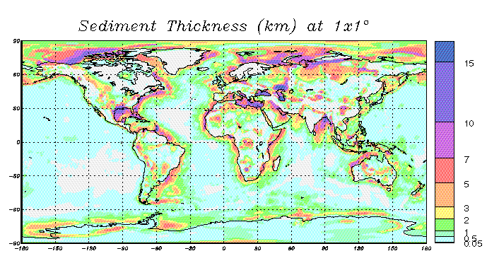
Response: The issue of how thick sediment sequences were deposited on top of today’s continents during the Flood and managed to be preserved there, while relatively little sediment on average is found today in the deep ocean basins, is definitely an important one. This would seem to be even more of an issue if the earth underwent multiple flips that produced gigantic tsunami-like waves that swept across the continents, as I have recently suggested. Before I address that issue specifically, I think it helpful to consider the actual distribution of sediment we find on the earth today. The map below, prepared by Gabi Laske and Guy Masters at the Scripps Institution of Oceanography at the University of California, San Diego, provides a global view of this distribution. It is noteworthy that the thickest accumulations of sediment actually occur in the ocean basins immediately adjacent to continental areas, for example, in the Gulf of Mexico off the Texas coast, in the Arctic off the coasts of Alaska, Canada, and Russia, in the Indian Ocean at the mouth of the Ganges River, and in the Mediterranean, Black, and Caspian Seas. So while the vast majority of the ocean bottom has very little sediment accumulation, near many of the continent margins sediment thickness in the ocean basins can be extreme.

In regard to this question, let me affirm strongly that understanding the processes which generated the thick and commonly quite laterally extensive sedimentary deposits that blanket the continents represents an exceedingly important research task crucial to defending the Flood. Recognizing this as an urgent task, ICR in 2006 initiated a new research thrust entitled Flood Activated Sedimentation and Tectonics (FAST) to begin to address the many issues involved. Leading this research initiative is Dr. Steve Austin of ICR. The first FAST workshop was held in St. George, Utah, in May, 2006, and an annual workshop has been held in each of the successive years.
One emphasis of FAST is to understand concentrated gravity driven flows of different types such as mudflows, hyperconcentrated flows, and debris flows. It is Steve Austin’s conviction that a considerable fraction of the sedimentary deposits formed during the Flood are in this category. It is my conviction that many other deposits were generated by tractive currents and less concentrated suspensions of particles. Our understanding of all these processes, however, in my assessment is still quite rudimentary. Our grasp of the topography of the continental regions during the Flood and how this topography was changing with time as the Flood unfolded is also still in its infancy. Moreover, the forcing that could have generated coherent currents thousands of kilometers in lateral scale across the continental regions is still largely speculative. In short, our ability to account for the continental sediment record in terms of the Flood at this point in time is meager at best. I believe we should be praying earnestly for the financial resources as well as qualified and motivated people to undertake this research.
Despite our ignorance on many of these crucial issues, the question remains as to how such thick sediment sequences managed to accumulate on the continents and also why so little sediment is to be found on most of the ocean bottom. I believe there are some rather simple answers that go a long way toward accounting for these observations. First of all, the sediment load that water can transport depends strongly on water velocity. And for a given water flux, measured in kg/m2, water velocity increases as the water depth decreases. Generally speaking, especially if one is thinking of sheet flow as opposed to channelized flow, high velocity is associated with shallow water, and vice versa. At the interface between continent and ocean basin, as water depth increases abruptly, velocity associated with sheet-like flow has a strong tendency to decrease abruptly. Hence, particles maintained in suspension due to high velocity turbulence will tend to drop out of suspension and be deposited as water velocity decreases. Similarly, particles of a given size class on the bottom which are being moved along by the traction of rapidly moving water move forward no longer when the water velocity drops below a certain threshold value. In short, deep water represents a sort of barrier to several types of sediment transport.
Even in the case of concentrated gravity flows that occur because of topographical relief in a continent interior, once the slope flattens out, the flow eventually loses it coherence, dissipative processes begin to take over, and transport comes to a halt. This is not to say that gravity collapse at the edge of a continental shelf does not produce spectacular gravity flows into the deep ocean. But even these flows can run out only so far once the relief disappears. Certainly such flows must have occurred during the Flood just as they happen today. Yet, I believe the case can be made that the shallower water over the continents during the Flood led to distinctly higher water velocities over the continent surfaces, which, in turn, produced much more intense erosion, much more effective sediment transport, and thicker deposits of sediment on top of the continents relative to the ocean basins.
One prominent reason for the paucity of sediment over most of the ocean bottom, in addition to the great water depth, is that all the pre-Mesozoic ocean bottom, and even much of the ocean floor formed in the Pacific since that point, has been recycled into the mantle by subduction. For the most part, there are no significant sources of sediment near the mid-ocean ridges where the new ocean floor is generated. Generally speaking, it is only on what are referred to as ‘passive margins’ of ocean basins, where no subduction is presently occurring, that sediments eroded from adjacent continent areas can accumulate. This can be clearly seen on the map of sediment thickness shown above for the cases of North and South America. Off the west coasts where subduction is active or has recently been active, there is generally no significant sediment accumulation. By contrast, off the east coasts of these continents, which are passive margins, there are thick accumulations of sediment.
Where did all the sediment from the subducted ocean plates go? The evidence from subduction zones active during the Flood, such as the one corresponding to the Franciscan terrane along the central California coast (discussed in my answer to question 4), strongly suggests that huge amounts of sediment were actually carried down the subduction zones during the Flood. The case is strong that melting of these subducted sediments generated the staggering volume of granitic magma that was emplaced along the western margin of North, Central, and South America during the Flood. (See the maps of these massive plutonic bodies along the west coasts of North and South America in my answer to question 30.) This granite includes, for example, that forming the Sierra Nevada range in California today as well as the Peninsular Ranges Batholith that extends into much of Baja California. My house in the foothills northeast of San Diego is built on this Cretaceous granite, derived from melted sediment and emplaced in crustal rock above the rapidly subducting Farallon Plate during the Flood.