CPT Q. 008: Is subduction geometrically possible only along a straight line?
Q. 8. Is subduction geometrically possible only along a straight line?
Response: According to GPS measurements, subduction is taking place today into the arc-shaped Aleutian Trench, the arc-shaped Sumatra Trench, and many other trenches that are far from straight lines. The error in the belief that subduction can occur only along a straight line is a failure to recognize that a subducting plate deforms as it plunges into the mantle. Many papers in the peer-reviewed literature provide strong seismic evidence that subducted slabs tear and deform dramatically in their journey downward into the mantle.
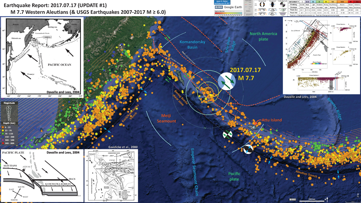
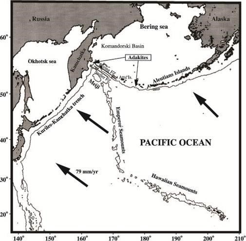
One location where slab tear is almost a certainty is at the Aleutian-Kamchatka corner. In the paper by Davaille and Lees, “Thermal modeling of subducted plates: tear and hotspot at the Kamchatka corner,”1 the authors ask:
“How can the Pacific Plate, which is subducting at an oblique angle in the western Aleutians, physically connect to the relatively steeply dipping Kamchatka slab to the west?”
They continue:
“The surficial manifestation of the connection is the massive Bering transform zone (TZ), extending from Attu Island westward towards Kamchatka (see figure below). In Kamchatka the margin between the Pacific Plate and North America takes a sharp turn southwards, towards the Kurile Trench and Japan. How does the Pacific Plate accommodate this sharp apparent bend? Does the Pacific plate drape over the corner as a tablecloth folds around a table corner, or is the Pacific Plate torn at the corner along the TZ to accommodate the deformation? In this paper we explore evidence and implications for the latter hypothesis.”
The authors do make a strong case that there is a tear in the Pacific Plate along the Bering Fracture Zone.
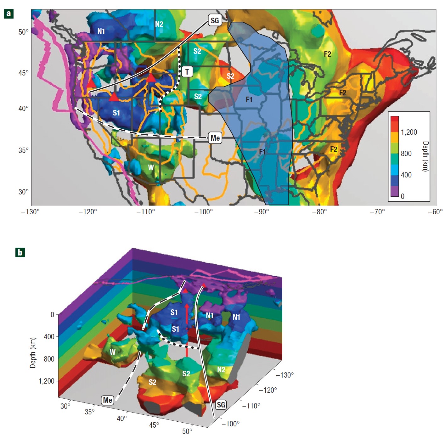
The extreme deformation that subducted slabs undergo is beautifully illustrated in a recent paper by Sigloch and Nolet entitled: “Two-stage subduction history under North America inferred from multiple-frequency tomography.”2 Figure 2 from this paper, reproduced below, shows via seismic tomography the present shape of the Farallon Plate, which has subducted beneath the western coast of North America since the earliest Jurassic and continues to do so as the modern Juan de Fuca Plate along the coasts of Oregon and Washington. The authors infer from the seismic data as well as from numerous surface observations that this plate underwent a large amount of tearing in its complicated history.
Studies on the way slabs deform after they subduct reveal that they can and do undergo extreme deformations, including tears. Most of the studies utilize seismology to provide actual images of these deforming masses of rock inside the earth. The fact that subducted slabs can and do deform means that geometrical constraints that would apply to perfectly rigid slabs do not apply to the real ones. This conclusion is valid not only in the case of the uniformitarian framework but also in the case of CPT.
-
A. Davaille and J. M. Lees, “Thermal modeling of subducted plates: tear and hotspot at the Kamchatka corner,” Earth Planet. Sci. Lett. 226 293-304, 2004 ↩︎
-
K. Sigloch, N. McQuarrie, and G. Nolet, “Two-stage subduction history under North America inferred from multiple-frequency tomography,” Nature Geosciences, 1, 458-462, 2008, see here. ↩︎